Hardback : HK$795.00
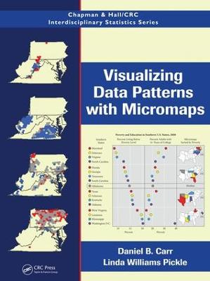
After more than 15 years of development drawing on research in cognitive psychology, statistical graphics, computer science, and cartography, micromap designs are becoming part of mainstream statistical visualizations. Bringing together the research of two leaders in this field, Visualizing Data Patterns with Micromaps presents the many design variations and applications of micromaps, which link statistical information to an organized set of small maps. This full-color book helps readers simultaneously explore the statistical and geographic patterns in their data.
After illustrating the three main types of micromaps, the authors summarize the research behind the design of visualization tools that support exploration and communication of spatial data patterns. They then explain how these research findings can be applied to micromap designs in general and detail the specifics involved with linked, conditioned, and comparative micromap designs. To compare and contrast their purposes, limitations, and strengths, the final chapter applies all three of these techniques to the same demographic data for Louisiana before and after Hurricanes Katrina and Rita.
Supplementary websiteOffering numerous ancillary features, the book’s website at http://mason.gmu.edu/~dcarr/Micromaps/ provides many boundary files and real data sets that address topics, such species biodiversity and alcoholism. One complete folder of data examples presents cancer statistics, risk factors, and demographic data. The site includes CCmaps, the dynamic implementation of conditioned micromaps written in Java, as well as a link to a generalized micromaps program. It also contains R functions and scripts for linked and comparative micromaps, enabling re-creation of all the corresponding examples in the book.
Show moreAfter more than 15 years of development drawing on research in cognitive psychology, statistical graphics, computer science, and cartography, micromap designs are becoming part of mainstream statistical visualizations. Bringing together the research of two leaders in this field, Visualizing Data Patterns with Micromaps presents the many design variations and applications of micromaps, which link statistical information to an organized set of small maps. This full-color book helps readers simultaneously explore the statistical and geographic patterns in their data.
After illustrating the three main types of micromaps, the authors summarize the research behind the design of visualization tools that support exploration and communication of spatial data patterns. They then explain how these research findings can be applied to micromap designs in general and detail the specifics involved with linked, conditioned, and comparative micromap designs. To compare and contrast their purposes, limitations, and strengths, the final chapter applies all three of these techniques to the same demographic data for Louisiana before and after Hurricanes Katrina and Rita.
Supplementary websiteOffering numerous ancillary features, the book’s website at http://mason.gmu.edu/~dcarr/Micromaps/ provides many boundary files and real data sets that address topics, such species biodiversity and alcoholism. One complete folder of data examples presents cancer statistics, risk factors, and demographic data. The site includes CCmaps, the dynamic implementation of conditioned micromaps written in Java, as well as a link to a generalized micromaps program. It also contains R functions and scripts for linked and comparative micromaps, enabling re-creation of all the corresponding examples in the book.
Show moreAn Introduction to Micromaps. Research Influencing Micromap Design. Data Visualization Design Principles. Linked Micromaps. Conditioned Micromaps. Comparative Micromaps. Putting It All Together. Appendices. References. Index.
Daniel B. Carr is Professor of Statistics at George Mason University in Fairfax, Virginia. Building on his early experience in developing static and dynamic graphics at Pacific Northwest National Laboratory, Dr. Carr continues to use new data as the motivation to create new graphics. He has taught statistical graphics to hundreds of graduate students in the computational data sciences. For more than 30 years, he has developed graphical and computational methods for exploratory visualization and has collaborated with researchers at several federal agencies, including working with Dr. Pickle at the National Cancer Institute (NCI). Dr. Carr is a Fellow of the American Statistical Association.
Linda Williams Pickle is principal and chief statistician at StatNet Consulting, LLC in Gaithersburg, Maryland, and Adjunct Professor of Geography and Public Health Services at Pennsylvania State University. She has devoted more than 30 years to the cancer research community, working for the National Cancer Institute (NCI), the Vincent T. Lombardi Comprehensive Cancer Center at Georgetown University, and the National Center for Health Statistics (NCHS). Dr. Pickle has published extensively about the spatial patterns of disease, including the award-winning Atlas of United States Mortality, which was the first of its kind to use statistical modeling in the background and to produce age-specific mortality rates based on modeled data. She is a Fellow of the American Statistical Association.
This is an interesting book written by two experts in the field
with more than 15 years of productive research in the area of
micromaps. … The authors have created examples using R functions
and scripts provided on a Web site. In the last chapter the authors
apply the three types of micromap to demographic data for Louisiana
state. It is a very practical way of finishing this fascinating
book. I strongly recommend this book to anyone who is interested in
data visualization techniques. Micromaps are applicable to data
from a wide range of disciplines. …
—M. Dolores Ugarte, Journal of the Royal Statistical Society,
Series A, 2012The book is well-written and nicely organized …
Overall, I found the book is well-researched and informative. It
uses lucid and easy-to-understand language. Additionally, the book
contains numerous colorful micromap variations that visually
illustrate design principles and real-world applications. It
clearly shows the authors’ enthusiasm for micromaps and their deep
knowledge of the subject. … I highly recommend this book for a
diverse audience who are interested in exploring and presenting
their data in a joint statistical and spatial context. … an
excellent text for graduate courses in data visualization. The
authors clearly succeeded in making this book suitable for teaching
by providing both theoretical foundations and practical examples
for designing effective visualization tools. An attractive feature
of the book is that it has a companion website … I congratulate the
authors for this great book. It will be an excellent addition to
the data visualization literature and I will definitely use it as
my reference.
—Samson Y. Gebreab, The American Statistician, August
2011[M]icromaps are an effective tool and the book explains them at
length, with lots of examples, so that non-statisticians can
understand and use them. … the graphic displays in this book are
clear and straightforward …
—International Statistical Review, 2011 The book is extremely well
written. I was totally absorbed by chapters one through four. It is
obvious that the authors are in total command of the topic and
bring years of experience in the field to the project. The authors
understand what areas need special attention and explanation. The
language flows nicely and the text is illustrative and
entertaining. The limitations of micromaps are known and discussed.
The reader gains a good understanding of what they are for and what
they can and cannot accomplish.
—Oliver Schabenberger, SAS Institute Inc., Cary, North Carolina,
USAThis is a terrific book and it introduces some clever tools.
—David Berrigan, NIH/NCI
Ask a Question About this Product More... |
